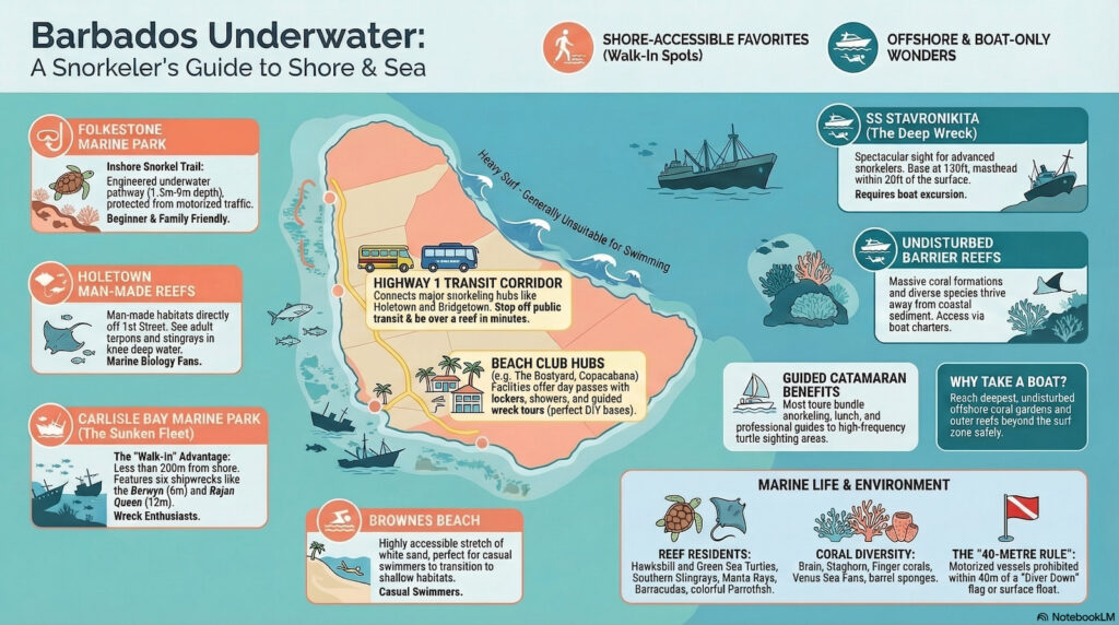
Barbados presents a remarkably diverse underwater topography that caters to everyone from the casual shore-wading novice to the advanced free diver. The fundamental layout of the island’s marine environment is defined by its distinct coastlines. The sheltered, calm waters of the Caribbean Sea on the island’s West Coast and South Coast are engineered for straightforward shore entries, allowing swimmers to walk directly from the sand into biologically dense marine habitats. Conversely, the Atlantic-facing East Coast is dominated by heavy surf and unpredictable rip currents, rendering it generally unsuitable for recreational swimming. Understanding this geographical divide is the first step in planning your aquatic itinerary.
To navigate this landscape effectively, you must divide the available sites into two strict categories: shore-accessible beaches and boat-only offshore reef systems. The former allows for absolute scheduling freedom, while the latter requires coordinating with local charter operators. For a complete breakdown of how seasonal weather cycles and shifting water temperatures affect visibility on these coasts, consult our comprehensive Best Time & Weather for Snorkelling guide.
Categorising Barbados Snorkelling Locations
The distinction between shore dives and boat excursions dictates your daily logistics. Shore accessibility in Barbados is world-class, particularly around the Bridgetown and Holetown corridors. Here, you can literally step off public transit and be floating above historic shipwrecks within ten minutes. However, the outer barrier reefs—where the most significant coral formations reside—sit far beyond the safe swimming perimeter.
| Snorkelling Location | Entry Type | Target Audience | Logistics & Access |
|---|---|---|---|
| Folkestone Marine Park | Shore & Boat | Beginners & Families | Public Transit / Rental Car |
| Carlisle Bay Marine Park | Shore & Boat | Wreck Divers & Turtle Spotters | Walk from Bridgetown Centre |
| Holetown Reefs | Shore & Boat | Marine Biology Enthusiasts | Public Transit to 1st Street |
| Brownes Beach | Shore | Casual Swimmers | Public Transit / Walking |
DIY Snorkelling Mapping Strategy
Independent Exploration
For the independent traveller, mapping out a multi-spot itinerary is incredibly straightforward. Major aquatic hubs are seamlessly connected via the island’s reliable public transit system, specifically the yellow reggae buses and blue government buses that run the length of Highway 1. You can easily begin your morning exploring the shallow shipwrecks at Brownes Beach, then take a short, 20-minute ride up the Platinum Coast for an afternoon at a protected marine reserve.
Shore facilities drastically improve the DIY experience. At Lower Bay Street, the Copacabana Beach Club features a massive 1,000-patron capacity right on the sand, offering air-conditioned showers and secure luggage storage for travellers who have just arrived from the airport. Further up the beach, The Boatyard operates a highly efficient entry credit system for the 2025/2026 season. Non-residents pay a $40 USD day pass, which crucially includes a 45-minute guided shipwreck tour and $20 USD redeemable in bar and restaurant credit.
Guided Offshore Excursions
While independent mapping offers freedom, some of the most complex offshore coral systems are physically inaccessible without a vessel. Operators providing guided catamaran excursions typically bundle deep-water reef access with lunch and open bar service. These vessels drop anchor safely outside the surf zone, allowing you to drop directly onto undisturbed habitats.
For mixed groups of swimmers and non-swimmers, specialised boats offer distinct advantages. For instance, you can book the Tranquility Cruises Turtle and Shipwreck Adventure, which departs from Pirate’s Cove in Carlisle Bay. This specific vessel is equipped with onboard waterslides, easy-boarding ramps, and glass-bottom viewing areas, ensuring that passengers of varying athletic abilities can observe the wrecks simultaneously. To view our full breakdown of charter operators, consult our Guided Tours & Lessons directory.
The West Coast: Sheltered Waters and Marine Parks
Folkestone Marine Park’s Protected Zones
Considered the premier West Coast destination for both beginner and intermediate swimmers, the Folkestone Marine Park operates as a meticulously managed sanctuary. The park’s primary advantage is its strict zoning protocol. To ensure absolute swimmer safety for the 2025/2026 season, the park follows Barbados Marine Trust guidelines, which include a “40-Metre Rule.” Under these guidelines, no motorised vessel may pass within 40 metres of a deployed “Diver Down” flag or surface float. This critical separation between commercial boat traffic and recreational zones allows you to navigate the water without the physical threat of jet skis or speedboats. As an officially recognised marine reserve supported by the Barbados Tourism Marketing Inc., it remains one of the most heavily monitored eco-attractions in the country.
The Folkestone Inshore Snorkel Trail
For those eager to bypass boat charters entirely, the Folkestone Inshore Snorkel Trail presents an engineered underwater pathway tailored for immediate access. The designated trail begins exactly 10 metres from the shoreline. Swimmers follow a bathymetric gradient that starts at a standing depth of 1.5 metres but drops quickly down to 9 metres. Because of this quick drop-off, buoyancy aids are essential for safety, and the trail is not recommended for children or first-time mask users without a life vest. Proper equipment is vital here; review our Equipment & Safety Guide before attempting the deeper sections of the trail.
Coral Species and Clarity at Folkestone
The defining characteristic of Folkestone’s protected recreational zone is its exceptional water clarity. Without the constant churning of boat propellers, suspended sediment remains minimal. This provides unobstructed visibility of specific, delicate marine life. Snorkellers routinely observe swaying Venus Sea Fans (Gorgonia ventalina), intricate colonies of Finger Coral, and occasionally, rare Sea Lilies (Crinoids) clinging to the limestone substrate. Moving slightly offshore into the deeper boat-access zones, advanced free divers can witness the SS Stavronikita. Deliberately scuttled in 1978 to create an artificial reef, the base of this massive shipwreck rests at a crushingly deep 120 to 130 feet. However, its colossal masthead rises to within just 6 metres (20 feet) of the surface. This makes the upper superstructure clearly visible to surface swimmers exploring the outer limits of Folkestone Marine Park, situated just north of the main Holetown, Barbados commercial centre.
Holetown Man-Made Reefs
Just south of Folkestone lies Holetown Beach, another highly accessible West Coast location. Specifically, the waters directly in front of the Calma Beach Club (accessible via 1st Street) host two distinct man-made reef structures. These artificial habitats were constructed to combat coastal erosion but have since become thriving ecosystems. Swimmers can stand in knee-deep water and frequently spot large adult tarpons and southern stingrays feeding near the shore break. For shore logistics, the Calma Beach Club offers premium sun-loungers on a first-come, first-served basis. Current 2025/2026 pricing stands at $60 BBD (approximately $30 USD) for two beds and an umbrella for the entire day, providing an excellent base of operations.
When exploring the bustling marine habitats of Carlisle Bay and Folkestone, remember that you are a guest in a fragile ecosystem. As documented by the Barbados Sea Turtle Project, maintaining a respectful physical distance is non-negotiable for preserving these magnificent creatures for generations to come.
Carlisle Bay and The Sunken Fleet
While the West Coast excels in coral preservation, the South-West corner of the island dominates in artificial reef structures. Carlisle Bay is globally recognised for its “Sunken Fleet,” a dense concentration of six shipwrecks intentionally placed to foster marine life. What makes this location structurally unique is its proximity to the shore. The entire fleet is remarkably accessible for shore snorkellers, sitting less than 200 metres (about 200 yards) off the beach directly opposite the Bay Street bandstand.
The depths and orientations of these wrecks vary, providing layered experiences. The Berwyn tugboat, scuttled by its own French crew in 1919, rests in just 6 metres of water. Its heavily encrusted upper superstructure reaches an incredibly shallow 2 to 3 metres below the surface depending on the tide, allowing you to float mere inches above decades of coral growth. Nearby sits the Bajan Queen, originally the “Pelican” tugboat from the 1960s. As the largest wreck in Carlisle Bay, its hull bottom rests at 12 metres, yet its top deck sits just 3 metres below the surface, making its prominent bridge and spiral staircase highly visible from above.
For those interested in maritime history, the bay holds further oddities. The Ce-Trek, sunk in January 1986, rests at a 12-metre depth and is entirely unique as a 45-foot derelict vessel constructed entirely from ferro-cement (concrete). Further out is the Eilon, a 110-foot former Colombian drug-running boat scuttled on June 8, 1996. It features a famous air pocket in its bow at a depth of exactly 7.5 metres—though local dive masters strictly advise that the trapped air is highly toxic and unsafe to breathe. Finally, the Cornwallis, a Canadian freighter originally torpedoed by a German U-boat during WWII, was physically relocated into the Carlisle Bay Marine Reserve on October 22, 2003, to protect its remains from heavy commercial boat traffic. For an exhaustive history of these vessels, read our dedicated Guide to Carlisle Bay Shipwrecks.
Frequently Asked Questions About Snorkelling Locations
Below we address the most common logistical and geographical questions regarding Barbados’ underwater sites, ensuring you have the exact data needed for a successful trip.
- Can I access the shipwrecks in Carlisle Bay directly from the shore?
Yes, absolute shore access is one of Carlisle Bay’s greatest advantages. The entire “Sunken Fleet” is located less than 200 metres from the shoreline opposite the Bay Street bandstand. Wrecks like the Berwyn sit in just 6 metres of water, with their uppermost structures reaching within 2 to 3 metres of the surface, making them easily viewable without a boat. - Which snorkelling spots are engineered specifically for absolute beginners?
Folkestone Marine Park stands out as the definitive location for novices. It features a designated Inshore Snorkel Trail that begins exactly 10 metres from the beach and follows a gentle gradient dropping from 1.5 to 9 metres deep. Furthermore, the Barbados Marine Trust’s strict 40-Metre Rule ensures no motorised vessels pass within 40 metres of a “Diver Down” flag. - Do I need to rent a car to reach the best snorkelling beaches?
Renting a vehicle is entirely optional due to the island’s highly efficient Highway 1 transit corridor. The most popular hubs, including Holetown and Carlisle Bay, are heavily serviced by public buses running every few minutes. Additionally, facilities like the Copacabana Beach Club on Lower Bay Street offer luggage storage and showers, making bus transit highly practical. - Are there locations where I absolutely have to book a boat tour?
While shore access is excellent, reaching the deepest, undisturbed offshore coral gardens requires a vessel. You will need to book an excursion to comfortably view deep-water spectacles like the SS Stavronikita at Folkestone, whose base rests at 130 feet, or to explore the outer barrier reefs away from the coastal sediment. We recommend reading our Guided Tours page for charter specifics. - Where can I safely and ethically swim with sea turtles?
Carlisle Bay and Paynes Bay are globally recognised for high-frequency sightings of resident hawksbill turtles. Because these areas see heavy human traffic, it is vital to practice strict hands-off etiquette. To understand the local laws and biological needs of these animals, consult our Responsible Turtle Encounters guide before entering the water.
Whether you choose to base yourself at the well-equipped facilities of The Boatyard or seek the quiet, engineered trails of Folkestone Marine Park, Barbados offers a highly structured, safe, and easily navigable marine environment. If you want to dry off and explore the terrestrial highlights of the island, check out our guide on Other Things to Do in Barbados.
Top Locations GPS Directory
To construct your own Barbados snorkelling map, rely on precise geographical coordinates rather than vague beach names. Pinpointing exact entry zones ensures you bypass heavy boat traffic and locate the most productive reef systems immediately. Finding the best snorkelling in Barbados requires tactical planning, particularly regarding parking and transit times. Use the following GPS markers and logistical data to navigate directly to the island’s primary underwater structures.
- Folkestone Marine Park (13.1896° N, 59.6424° W): Located approximately 8 miles north of the Bridgetown Cruise Terminal. Enter precisely at the visitor centre boundary. The inshore trail begins 10 metres from the high-water mark, dropping to a 9-metre depth. Free public parking is available but fills rapidly before 9:00 AM. Expect exceptional underwater visibility ranging from 50 to 95 feet.
- Carlisle Bay Shipwrecks (13.0882° N, 59.6144° W): Situated less than 1 mile from the Bridgetown Cruise Terminal, making it highly accessible for day-trippers. Navigate 200 metres seaward from the Bay Street bandstand. This coordinate places you directly over the central wreck zone, where the Bajan Queen rests at a 12-metre depth with its upper deck just 3 metres below the surface.
- Holetown Artificial Reefs (13.1795° N, 59.6415° W): Wade in directly opposite the Calma Beach Club on 1st Street. The structures sit in mere 1.5-metre shallows.
Water conditions dictate your schedule. As of March 2026, the transition into the spring weather cycle brings highly stable marine environments. Average sea surface temperatures hover around 26.7°C (80.1°F) in March and climb slightly to 27.6°C (81.7°F) throughout April. These metrics eliminate the need for thick wetsuits; a standard rash guard provides sufficient thermal protection and defends against incidental coral scrapes. Enter the water before 9:00 AM. Early arrivals secure optimal visibility before the midday trade winds agitate the surface sediment.